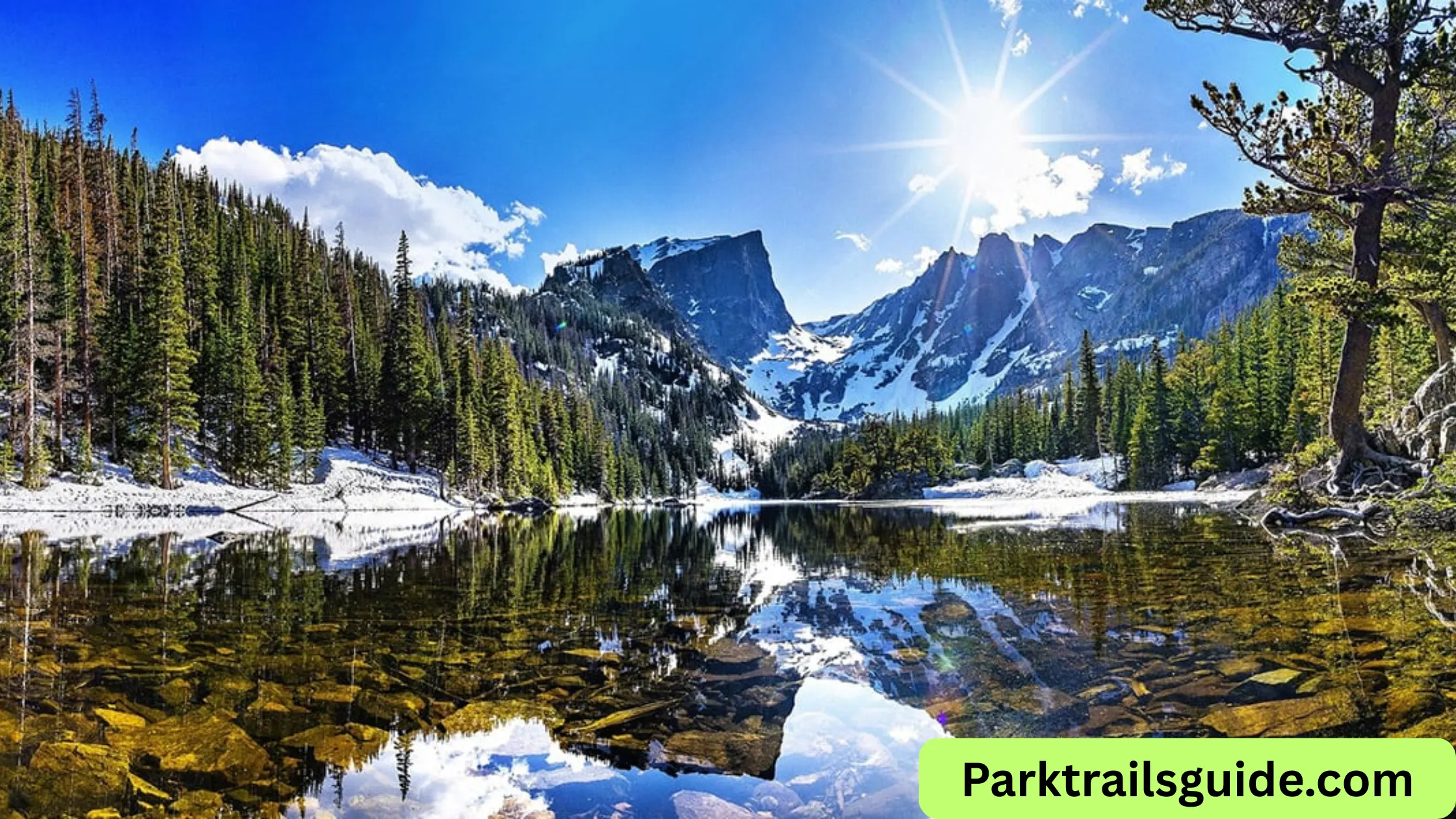
If you are planning a trip to Rocky Mountain National Park, one of the most important things you need is a good map. This park is large, beautiful, and full of different routes, scenic drives, and hiking trails. Without a proper map, it is easy to miss some of the best spots.
In this detailed guide, you will learn how to use the Rocky Mountain National Park map, understand the main routes, explore top hiking trails, and plan your visit in a simple and practical way.
Why You Need a Rocky Mountain National Park Map
Rocky Mountain National Park covers over 400 square miles. It has mountains, forests, lakes, and wildlife areas spread across a wide region. A map helps you:
- Find entrances and visitor centers
- Plan your driving routes
- Choose the best hiking trails
- Locate parking areas and rest stops
- Avoid getting lost in remote areas
Many regular visitors say that having both a digital and a paper map is the best way to explore the park safely.
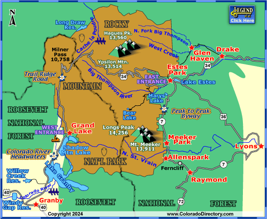
Main Areas on the Park Map
The park is divided into a few main regions. Understanding these areas will help you read the map easily.
1. Estes Park Side (East Entrance)
This is the most popular and busiest side of the park. It is close to the town of Estes Park and has easy access to many famous spots.
Key locations:
- Beaver Meadows Entrance
- Bear Lake Corridor
- Moraine Park
This area is best for first-time visitors.
2. Grand Lake Side (West Entrance)
This side is quieter and less crowded. It is perfect if you want a peaceful experience.
Key locations:
- Kawuneeche Valley
- Colorado River headwaters
- Grand Lake town
The west side is great for wildlife viewing and relaxing drives.
3. Alpine Tundra Area
This is the high-altitude region of the park. It is accessible mainly through Trail Ridge Road.
You will see:
- Open mountain views
- Snow even in summer
- Unique alpine plants
Understanding the Park Map Layout
When you look at a Rocky Mountain National Park map, you will notice:
- Roads marked clearly with curves and elevation changes
- Trailheads shown with symbols
- Campgrounds and parking areas labeled
- Lakes, rivers, and peaks highlighted
The map is designed to help you plan both driving and hiking routes.
Scenic Drives on the Map
Driving is one of the best ways to explore the park. The map highlights several scenic routes.
Trail Ridge Road
The most famous road in the park is Trail Ridge Road. It connects the east and west sides of the park.
Key features:
- One of the highest paved roads in the USA
- Elevation over 12,000 feet
- Stunning mountain views
Stops along the way include:
- Many Parks Curve
- Alpine Visitor Center
- Forest Canyon Overlook
This road is usually open from late spring to early fall, depending on weather.
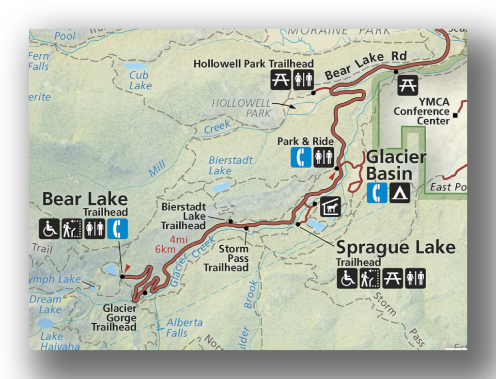
Bear Lake Road
This road is very popular because it leads to many famous hiking trails.
You can access:
- Bear Lake
- Sprague Lake
- Glacier Gorge
Parking fills up quickly here, so arrive early.
Best Hiking Trails on the Map
The Rocky Mountain National Park map includes many trails for all skill levels. Below are some of the most popular ones.
Easy Trails
Bear Lake Trail
- Distance: 0.6 miles loop
- Difficulty: Easy
This trail is perfect for beginners and families. It offers beautiful lake views and mountain reflections.
Sprague Lake Trail
- Distance: 0.8 miles loop
- Flat and wheelchair accessible
A great option if you want a relaxing walk with scenic views.
Moderate Trails
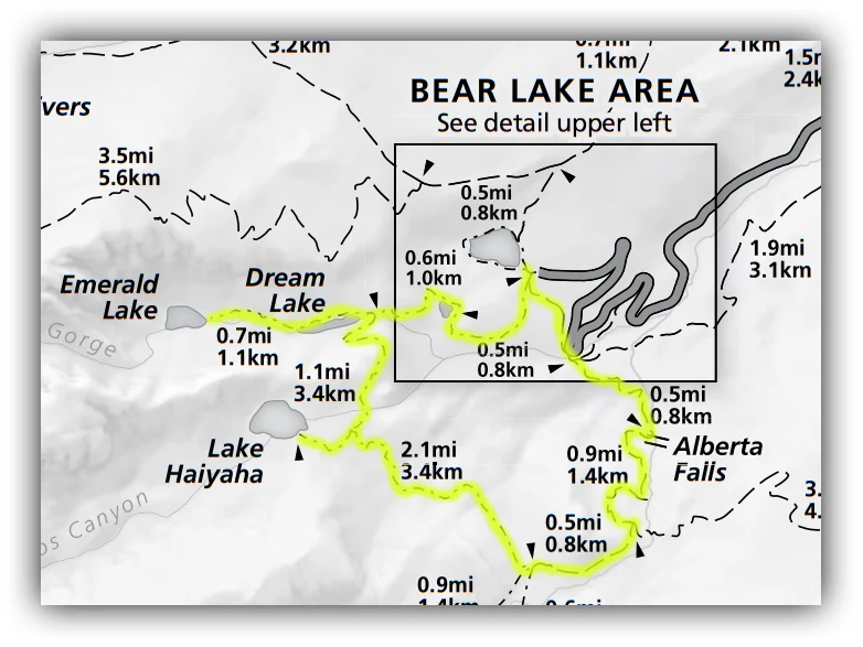
Emerald Lake Trail
- Distance: 3.2 miles round trip
- Difficulty: Moderate
This trail passes through:
- Nymph Lake
- Dream Lake
- Emerald Lake
It is one of the most popular hikes in the park.
Alberta Falls Trail
- Distance: 1.6 miles round trip
A short hike leading to a beautiful waterfall. It is busy but worth the visit.
Difficult Trails
Sky Pond Trail
- Distance: 9 miles round trip
- Difficulty: Hard
This trail includes:
- Waterfalls
- Steep climbs
- Stunning alpine lake views
Longs Peak Trail
The famous Longs Peak is the highest mountain in the park.
- Distance: 14+ miles
- Very challenging
This hike is only for experienced hikers. It requires preparation and early start times.
Trailheads and Parking Areas
Your map will show trailheads clearly. These are starting points for hikes.
Important tips:
- Arrive early, especially in summer
- Use park shuttle services when available
- Follow parking signs carefully
Popular trailheads include:
- Bear Lake Trailhead
- Glacier Gorge Trailhead
- Wild Basin Trailhead
Using the Map for Route Planning
To plan your day efficiently:
- Choose your entry point
- Mark the places you want to visit
- Check distances between stops
- Allow time for parking and walking
- Keep backup options in case of crowds
For example, a simple one-day plan:
- Enter from Estes Park
- Drive Bear Lake Road
- Hike Emerald Lake Trail
- Stop at Moraine Park
- Drive Trail Ridge Road
Digital vs Paper Maps
Digital Maps
You can use apps like:
- Google Maps
- AllTrails
Benefits:
- Easy navigation
- Live directions
- Trail reviews
But remember, mobile signal can be weak inside the park.
Paper Maps
You can get official maps at visitor centers.
Benefits:
- No battery needed
- Reliable in remote areas
- Easy to understand overall layout
Best practice is to carry both.
Wildlife and Safety on Routes
The park map also helps you understand wildlife zones.
Animals you may see:
- Elk
- Deer
- Moose
Safety tips:
- Keep distance from animals
- Stay on marked trails
- Carry water and snacks
- Check weather before hiking
Seasonal Map Differences
The park changes with seasons, and so does access.
Summer
- All roads usually open
- Busy season
- Best for hiking
Fall
- Fewer crowds
- Beautiful fall colors
- Elk activity
Winter
- Some roads closed
- Snow-covered trails
- Limited access areas
Always check current conditions before your visit.
Visitor Centers on the Map
Visitor centers are clearly marked and very useful.
Main centers:
- Beaver Meadows Visitor Center
- Fall River Visitor Center
- Alpine Visitor Center
Services include:
- Maps and guides
- Restrooms
- Information about trails and weather
Tips for First-Time Visitors
If this is your first visit, keep these tips in mind:
- Start early to avoid crowds
- Focus on one area per day
- Use the map to avoid backtracking
- Carry layers for changing weather
- Download maps offline
Many regular visitors say that planning your routes in advance makes your trip much more enjoyable.
Common Mistakes to Avoid
- Not checking road closures
- Underestimating hiking difficulty
- Relying only on mobile maps
- Ignoring altitude effects
Take your time and plan properly using the park map.
Final Thoughts
A good Rocky Mountain National Park map is your best tool for exploring this beautiful place. It helps you understand the layout, choose the right trails, and enjoy scenic routes without confusion.
Whether you are driving along Trail Ridge Road or hiking to Emerald Lake, the map makes your journey smoother and safer.
Plan ahead, follow marked routes, and take your time to enjoy everything this amazing park has to offer.
Read Also: Petrified Forest National Park Map: Trails & Routes

Rubie Rose is a travel writer with a focused specialty in USA national parks, hiking trails, and practical outdoor trip planning. She is the founder and lead writer of Park Trails Guide — an independent resource built to help everyday visitors explore America’s parks with real confidence, not just enthusiasm.