Planning a trip to Joshua Tree National Park becomes much easier when you understand its map. This desert park is huge, with different regions, entrances, roads, and hidden spots. If you visit without a clear idea of the layout, you may miss the best attractions.
This 2026 guide explains everything about the Joshua Tree National Park map in a simple and practical way. You will learn about routes, entrances, driving plans, and how to use the map efficiently for your trip.
Overview of Joshua Tree National Park Map
Joshua Tree National Park sits in southern California and covers nearly 800,000 acres. The park is where two deserts meet:
- Mojave Desert (north side) – famous for Joshua trees
- Colorado Desert (south side) – lower elevation, hotter climate
When you look at the map, you will notice that the park is long and wide, with limited paved roads. This makes route planning very important.
Key Areas on the Map
- Northwest (Joshua Tree Entrance) – closest to towns and popular spots
- North (Twentynine Palms Entrance) – quieter but scenic
- South (Cottonwood Entrance) – less crowded, desert landscapes
Each area offers a different experience, so your route should depend on your travel style.
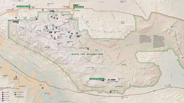
Joshua Tree National Park Entrances Explained
Understanding entrances is the first step in using the map correctly.
1. West Entrance (Joshua Tree Village)
This is the most popular entrance.
- Closest to main attractions
- Easy access for first-time visitors
- Best for short trips
If you are visiting for one day, this is the best starting point.
2. North Entrance (Twentynine Palms)
This entrance is less crowded.
- Good for peaceful exploration
- Quick access to northern trails
- Ideal for sunrise visits
Many experienced travelers prefer this entry point.
3. South Entrance (Cottonwood)
This is the least busy entrance.
- Best for long drives
- Warmer desert scenery
- Fewer tourists
If you want a quiet and scenic route, this is a great option.
Main Roads on the Map
Joshua Tree has only a few main paved roads, but they connect most major attractions.
Park Boulevard
This is the most important road in the park.
- Connects West Entrance to North Entrance
- Passes through top attractions
- Perfect for first-time visitors
Most popular stops are located along this route.
Pinto Basin Road
This road runs north to south.
- Connects Park Boulevard to Cottonwood Entrance
- Offers desert views
- Less traffic
It is great for longer scenic drives.
Keys View Road
A short side road leading to a viewpoint.
- Offers panoramic views
- Easy detour from Park Boulevard
Best Routes Using the Map
Here are the best routes depending on how much time you have.
1-Day Route (Most Popular)
Start: West Entrance
End: North Entrance
Route Plan:
- Hidden Valley
- Barker Dam
- Skull Rock
- Keys View
- Arch Rock
This route covers the main highlights in one day. It is simple and efficient.
2-Day Route (Balanced Trip)
Day 1:
- Enter from West Entrance
- Explore central attractions
- Sunset at Keys View
Day 2:
- Drive Pinto Basin Road
- Visit Cholla Cactus Garden
- Exit via Cottonwood
This plan gives you a mix of popular and quiet areas.
Full Park Drive (Long Scenic Route)
Start: South Entrance
End: North Entrance
This route covers the entire park from south to north.
- See both desert ecosystems
- Experience changing landscapes
- Ideal for photography
Important Map Highlights
When using the Joshua Tree map, these locations are must-see:
Hidden Valley
- Easy walking trail
- Surrounded by rock formations
- Great for beginners
Skull Rock
- Unique rock shaped like a skull
- Located right beside the road
- Quick stop
Keys View
- One of the best viewpoints in the park
- Overlooks Coachella Valley
Cholla Cactus Garden
- Dense cactus area
- Best visited during sunrise or sunset
Arch Rock
- Natural rock arch
- Short hike required
Hiking Trails on the Map
Joshua Tree offers many hiking options. The map shows trails clearly, but it is important to choose based on your fitness level.
Easy Trails
- Hidden Valley Trail
- Barker Dam Trail
Moderate Trails
- Ryan Mountain
- Arch Rock Trail
Longer Trails
- Lost Horse Mine Trail
- Fortynine Palms Oasis
Always check the trail location on the map before starting.
Tips for Using the Joshua Tree Map
Here are some practical tips to avoid confusion:
1. Download Offline Maps
There is limited mobile signal inside the park. Always download maps before entering.
2. Carry a Paper Map
You can get a free map at the entrance. It is reliable and easy to use.
3. Plan Fuel Stops
There are no gas stations inside the park. Fill your tank before entering.
4. Start Early
Parking areas fill up quickly, especially near popular spots.
5. Follow Marked Roads
Do not drive off-road unless allowed. Stick to marked routes.
Best Time to Use the Map
The time of your visit affects how you use the map.
Winter (Best Season)
- Pleasant weather
- Ideal for hiking
- Easy navigation
Spring
- Wildflowers bloom
- Moderate crowds
Summer (Challenging)
- Very hot
- Limited outdoor activities
- Plan shorter routes
Fall
- Good weather
- Fewer crowds than spring
Map Planning for First-Time Visitors
If this is your first visit, keep things simple:
- Enter from the West Entrance
- Follow Park Boulevard
- Visit major attractions
- Avoid long detours
Do not try to cover the entire park in one day. It is better to enjoy fewer places properly.
Parking and Navigation Tips
- Popular spots have small parking areas
- Arrive early to get space
- Follow signs carefully
- Do not rely only on GPS
Using both GPS and a physical map is the best approach.
Safety Tips While Using the Map
Joshua Tree is a desert environment, so safety is important.
- Carry enough water
- Wear sun protection
- Stay on marked trails
- Inform someone about your plan
Always respect park rules and guidelines.
Photography and Scenic Stops
The map helps you find the best photography spots.
- Sunrise: Cholla Cactus Garden
- Sunset: Keys View
- Night Sky: Open desert areas
Joshua Tree is also famous for stargazing, so mark safe parking areas for night visits.
Also See: Glacier National Park Map Guide 2026: Routes & Tips
Frequently Asked Questions
Is Joshua Tree easy to navigate?
Yes, but only if you understand the main roads and entrances.
How long does it take to drive through the park?
A full drive can take 3 to 5 hours without stops.
Which entrance is best?
The West Entrance is best for first-time visitors.
Can I rely on Google Maps?
Not completely. Always carry an offline or paper map.
Are all roads paved?
Most main roads are paved, but some side roads are not.
Final Thoughts
The Joshua Tree National Park map is your most important tool for planning a smooth and enjoyable trip. With limited roads and a large landscape, knowing where to go saves time and helps you explore more.
Start with a clear route, choose the right entrance, and focus on key attractions. Whether you are visiting for a day or a weekend, proper map planning will make your experience much better.

Rubie Rose is a travel writer with a focused specialty in USA national parks, hiking trails, and practical outdoor trip planning. She is the founder and lead writer of Park Trails Guide — an independent resource built to help everyday visitors explore America’s parks with real confidence, not just enthusiasm.