Zion National Park is one of the most visited national parks in the United States, known for its dramatic red cliffs, narrow canyons, and scenic hiking trails. But if there’s one thing every visitor quickly realizes, it’s this: you need a good map to explore Zion properly.
During my first visit, I underestimated how important the park map would be. I thought I could rely on phone navigation, but signal drops in many areas. That’s when I learned that a Zion National Park map is not just helpful—it’s essential.
In this 2026 guide, you’ll learn how to use the Zion map effectively, understand shuttle routes, explore top trails, and plan your visit with confidence.
Zion National Park Map Overview
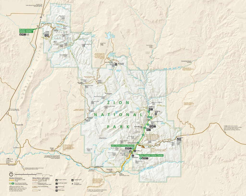
The Zion National Park map shows all major areas, including:
- Zion Canyon Scenic Drive
- Shuttle stops and routes
- Hiking trails and viewpoints
- Campgrounds and visitor centers
- Scenic drives outside the main canyon
Key Areas on the Map
| Area | Description |
|---|---|
| Zion Canyon | Main tourist area with shuttle access |
| Kolob Canyons | Less crowded, scenic viewpoints |
| East Rim | Unique rock formations and viewpoints |
| Kolob Terrace Road | Remote area with fewer crowds |
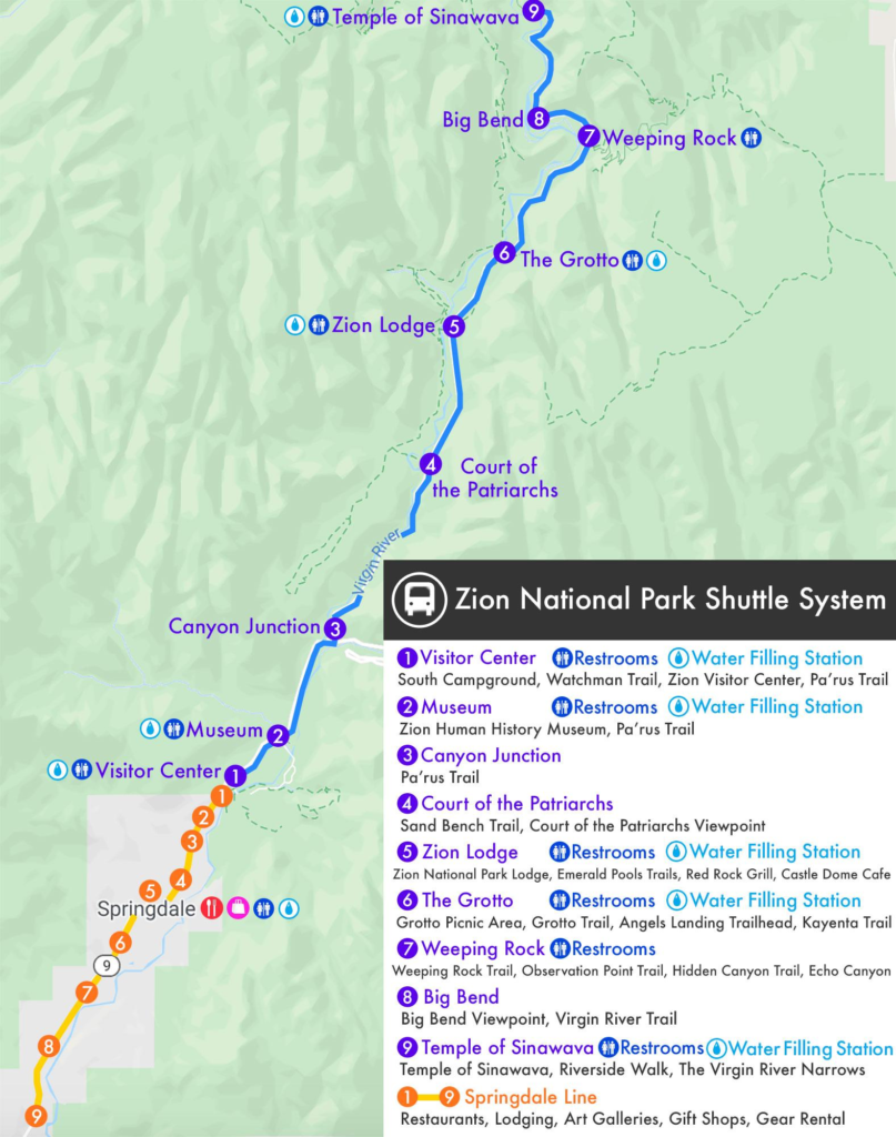
Zion Shuttle Map and Route Guide
One of the most important parts of the Zion map is the shuttle system.
Why the Shuttle Matters
Private vehicles are restricted on Zion Canyon Scenic Drive during most of the year. Instead, visitors use a free shuttle that runs between stops.
Main Shuttle Stops
- Visitor Center (Start point)
- Zion Human History Museum
- Canyon Junction
- Court of the Patriarchs
- Zion Lodge
- The Grotto (Angels Landing access)
- Weeping Rock
- Temple of Sinawava (Riverside Walk, Narrows)
Pro Tip
From personal experience, start early in the morning. The first shuttle is much less crowded, and you’ll have better access to popular trails like Angels Landing.
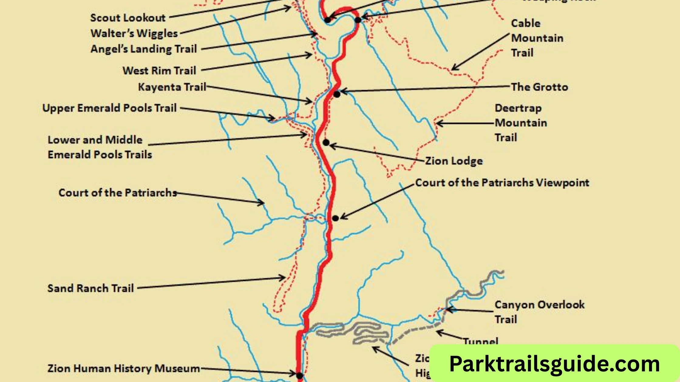
Best Hiking Trails on Zion Map
Zion is famous for its hiking trails, and the map helps you choose the right one based on your fitness level.
Easy Trails
- Riverside Walk
- Distance: 2.2 miles round trip
- Flat and family-friendly
- Leads to the Narrows
- Lower Emerald Pools
- Short and scenic
- Great for beginners
Moderate Trails
- Middle & Upper Emerald Pools
- Canyon Overlook Trail
- One of the best viewpoints in Zion
Difficult Trails
- Angels Landing
- Requires permit
- Narrow ridges and steep drops
- The Narrows (Top-Down or Bottom-Up)
- Hiking through water
- Weather-dependent
Trail Selection Tips
- Check the map for elevation gain
- Look at shuttle stops for access
- Avoid peak hours for popular trails
Scenic Drives and Routes
Not everyone wants to hike all day. Zion’s scenic drives are equally rewarding.
Zion-Mount Carmel Highway
- Includes a historic tunnel
- Offers stunning viewpoints
- Access to Canyon Overlook Trail
Kolob Canyons Scenic Drive
- Less crowded
- Beautiful red rock formations
- Ideal for short visits
Kolob Terrace Road
- Quiet and peaceful
- Great for avoiding crowds
How to Read the Zion National Park Map
Many first-time visitors find the map confusing. Here’s a simple way to understand it:
Symbols You Should Know
- Shuttle icons = bus stops
- Dotted lines = hiking trails
- Solid lines = roads
- Blue lines = rivers and water areas
Important Tips
- Always check distances between stops
- Pay attention to elevation changes
- Identify restrooms and water stations
From experience, marking your route beforehand helps avoid wasting time deciding inside the park.
Downloading and Using the Map Offline
Mobile networks are unreliable inside the park, so always prepare in advance.
Best Options
- Download PDF from official park website
- Use offline maps on apps like
- Google Maps
- AllTrails
What I Personally Do
I keep both a printed map and a downloaded version on my phone. This combination has saved me multiple times when navigating remote areas.
Best Time to Use Zion Map for Planning
The map becomes even more useful when planning according to the season.
Spring (March–May)
- Best weather
- Waterfalls active
- Moderate crowds
Summer (June–August)
- Very hot
- Early planning needed
- Shuttle becomes essential
Fall (September–November)
- Fewer crowds
- Pleasant temperatures
Winter (December–February)
- Snow on cliffs
- Some trails closed
Common Mistakes to Avoid
Even with a map, many visitors make avoidable mistakes:
- Not checking shuttle routes before arrival
- Underestimating hiking distances
- Relying only on mobile navigation
- Starting hikes too late in the day
- Ignoring weather warnings
Suggested 1-Day Itinerary Using Zion Map
If you have limited time, here’s a simple route:
Morning
- Start at Visitor Center
- Take shuttle to The Grotto
- Hike Angels Landing or Scout Lookout
Afternoon
- Visit Zion Lodge
- Explore Emerald Pools
Evening
- Head to Temple of Sinawava
- Walk Riverside Trail
This route covers major highlights efficiently.
Safety Tips While Using the Map
- Carry enough water (at least 2–3 liters per person)
- Check weather before hiking
- Avoid flash flood areas like the Narrows during rain
- Wear proper hiking shoes
- Follow park signs and ranger instructions
FAQs About Zion National Park Map
1. Where can I get the official Zion map?
You can get it at the Visitor Center or download it online before your trip.
2. Is the Zion shuttle map included in the main map?
Yes, the official map includes shuttle routes and stops.
3. Can I drive inside Zion National Park?
Private vehicles are restricted in Zion Canyon during peak seasons, so you’ll need to use the shuttle.
4. Is GPS reliable inside Zion?
No, signals are weak in many areas. Always carry an offline map.
5. What is the best trail shown on the Zion map?
Angels Landing and The Narrows are the most popular, but it depends on your fitness level.
Final Thoughts
A Zion National Park map is more than just a guide—it’s your key to exploring one of America’s most stunning landscapes efficiently and safely.
From my own experience, planning ahead using the map made a huge difference. Instead of feeling lost or overwhelmed, I was able to enjoy every moment, from sunrise hikes to peaceful canyon views.
If you’re visiting in 2026, take time to study the map before your trip. It will help you avoid crowds, choose the best trails, and make the most of your adventure.
Read Also: Rocky Mountain National Park Map: Trails & Routes

Rubie Rose is a travel writer with a focused specialty in USA national parks, hiking trails, and practical outdoor trip planning. She is the founder and lead writer of Park Trails Guide — an independent resource built to help everyday visitors explore America’s parks with real confidence, not just enthusiasm.