Highline Trail Glacier National Park: Complete Hiking Guide (2026)
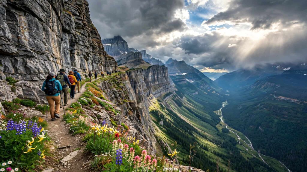
The Highline Trail in Glacier National Park is one of Montana’s most famous high-elevation hikes. Starting near Logan Pass, the trail follows the Garden Wall along the Continental Divide, with dramatic mountain views, alpine meadows, cliffs and wildlife along the way.
The full trail from Logan Pass to The Loop is 11.8 miles (19 km) one way, with about 2,388 feet of elevation gain and 4,773 feet of elevation loss.
For many visitors, however, hiking the entire 11.8 miles isn’t necessary. You can hike part of the Highline Trail and turn around, or continue toward Granite Park Chalet, Grinnell Glacier Overlook or The Loop, depending on your time, fitness and trail conditions.
2026 note: Glacier National Park’s trail status can change because of snow, wildlife activity and weather. The National Park Service currently lists a section of the Highline between Logan Pass and the Grinnell Glacier Overlook junction as closed because of bear activity, so check the official trail-status page immediately before hiking.
Highline Trail at a Glance
| Detail | Information |
|---|---|
| Location | Glacier National Park, Montana |
| Main trailhead | Logan Pass |
| Ending point | The Loop |
| Distance | 11.8 miles one way |
| Elevation gain | 2,388 ft |
| Elevation loss | 4,773 ft |
| Difficulty | Strenuous |
| Trail type | Point-to-point |
| Best season | Usually mid/late summer into early fall, depending on conditions |
| Main attraction | Garden Wall and alpine mountain views |
| Major hazards | Exposure, snow, storms, wildlife and steep terrain |
The National Park Service describes much of the Highline as exposed and notes that hikers should be especially aware of steep drop-offs and changing weather.
Where Is the Highline Trail?
The Highline Trail begins at Logan Pass, the highest point along the Going-to-the-Sun Road.
The trailhead is located across the road from the Continental Divide sign near the Logan Pass parking area.
Logan Pass is approximately halfway along the Going-to-the-Sun Road and is one of the most popular areas in Glacier National Park.

Because parking and access at Logan Pass can be complicated during the busy season, it’s important to plan transportation before arriving.
Highline Trail Route
The classic route begins at Logan Pass and travels westward along the mountainside before eventually descending toward The Loop.
1. Logan Pass Trailhead
The hike starts at a high elevation, so you don’t have a huge initial climb. Instead, the trail immediately takes you into exposed alpine terrain.
One of the first notable features is a narrow section along the mountainside. The National Park Service says portions of the trail can be only 3–5 feet wide, with a significant drop-off on one side. A hand cable is available along approximately 50 yards of the exposed section.
This is one of the reasons hikers should take their time at the beginning.
2. The Highline’s Cliffside Section

After the initial exposed section, the trail continues along the Garden Wall.
The scenery is the main attraction here. Looking away from the cliff, you’ll see enormous mountain slopes, valleys and peaks extending across Glacier National Park.
The trail isn’t simply a straight ridge walk. It winds around the mountain, crossing rocky sections and alpine terrain.
3. Haystack Butte
One of the recognizable landmarks along the route is Haystack Butte.
The area provides a good opportunity to pause, drink some water and assess the conditions ahead.
Snow can remain on higher sections of Glacier’s trails well into summer. The National Park Service notes that higher-elevation trails can have snow and other hazards until around mid-July, depending on the year.
4. Granite Park Chalet

One of the major destinations connected with the Highline Trail is Granite Park Chalet.
The chalet is an important landmark for hikers continuing beyond the initial Highline section. From the Highline, hikers can take the route toward Granite Park Chalet before continuing toward The Loop.
If you’re planning a long day hike, make sure you account for the return or transportation logistics rather than assuming the hike will simply end where you started.
The National Park Service specifically warns that hiking from one trailhead to another creates additional transportation and logistical challenges.
How Long Does the Highline Trail Take?
Your hiking time depends heavily on how far you go, your pace, stops, weather and trail conditions.
For the complete 11.8-mile Logan Pass-to-The Loop route, many hikers should plan for a substantial portion of the day rather than treating it as a quick hike.
A practical way to plan is:
- Short hike: Walk from Logan Pass for a few miles and return.
- Medium hike: Continue toward the Garden Wall/Granite Park area and turn around.
- Long hike: Continue toward Granite Park Chalet and The Loop.
- Full point-to-point hike: Logan Pass → The Loop.
The full route has considerably more elevation loss than gain because you start high at Logan Pass and finish much lower at The Loop.
Is the Highline Trail Difficult?
Yes. The Highline should be treated as a strenuous mountain hike, particularly if you’re attempting the full route.
The difficulty comes from several factors rather than elevation gain alone:
- Long overall distance
- High elevation
- Exposed trail sections
- Steep drop-offs
- Changing mountain weather
- Snow or ice early in the season
- Wildlife
- Rocky and uneven surfaces
- Transportation considerations for point-to-point hikes
The National Park Service specifically warns that much of the trail is exposed and that weather can significantly affect hiking conditions.
What about the scary section?
The first exposed section near Logan Pass is the part that concerns many hikers.
According to the National Park Service, some sections are only 3–5 feet wide with a large drop-off, while a hand cable is provided for roughly 50 yards.
If you’re uncomfortable with heights, consider hiking only as far as you feel comfortable and turning around.
Best Time to Hike Highline Trail in 2026

There isn’t one guaranteed opening date every year.
Glacier National Park explains that high-elevation trails can remain snowy well into summer, and popular trails such as the Highline may remain closed because of snow or wildlife activity.
July
July can provide access to the high country, but early July may still bring snow.
The park’s trail-status guidance says July is a transition period, with higher elevations potentially retaining snow hazards.
August
August is generally the period when the high country is most accessible, although conditions can still change after storms.
The NPS describes August as the period when high-country snow and water hazards are generally reduced, while emphasizing that conditions can change.
September
September can provide excellent hiking conditions, but weather becomes less predictable.
The park notes that some Septembers can be similar to August, while the possibility of significant snowfall increases.
Highline Trail Weather
Mountain weather can change quickly.
The National Park Service says Glacier’s weather is highly variable and can be extreme. Even during July and August, visitors should expect changing conditions and bring rain gear and additional layers.
Before starting the hike, check:
- Temperature
- Rain forecast
- Thunderstorms
- Wind
- Snow conditions
- Trail closures
- Wildlife postings
Don’t rely solely on the weather at your hotel or in the nearest town. Conditions at Logan Pass can be substantially different.
What to Bring on the Highline Trail
A good Highline Trail packing list includes:
Essential gear
- Plenty of drinking water
- High-energy snacks
- Hiking shoes or boots with good traction
- Rain jacket
- Warm layer
- Sun protection
- Hat and sunglasses
- First-aid supplies
- Navigation/map
- Fully charged phone
- Headlamp for longer hikes
- Bear spray where legally appropriate and according to current park guidance
Because cell service isn’t available throughout much of Glacier National Park, the NPS recommends planning ahead and taking screenshots or carrying appropriate maps.
Wildlife on the Highline Trail
Wildlife is another important consideration.
Glacier National Park is home to animals including bears and mountain goats. Trail conditions can change because of wildlife activity, and the park may close or post trails when necessary.
The current NPS trail-status system, for example, lists a section of the Highline with a bear-activity closure.
Always follow posted closures and wildlife instructions. Don’t approach, feed or attempt to photograph wildlife from an unsafe distance.
Highline Trail and the Garden Wall

The Garden Wall is one of the defining geological features of the Highline Trail.
As the trail follows the mountainside, the Garden Wall rises above and around the route while enormous valleys open below.
This combination of cliffs, alpine vegetation and distant mountain scenery is what makes the Highline different from many lower-elevation hikes in Glacier.
Can You Hike Highline Trail as a Beginner?
It depends on what you mean by “hike the Highline.”
A reasonably fit beginner who is comfortable with heights and mountain terrain may be able to walk a shorter section and turn around.
The full Logan Pass-to-The Loop route, however, is a long mountain hike with exposure and logistical considerations. It isn’t the type of trail where you should judge difficulty simply by looking at the elevation gain.
If you’re new to hiking, consider starting with a shorter Glacier trail before committing to the entire Highline.
Highline Trail Transportation in 2026
Transportation is particularly important because the classic Highline route is point-to-point.
The trail starts at Logan Pass and ends at The Loop.
In 2026, Glacier National Park introduced a ticketed Logan Pass shuttle service designed in part for visitors doing longer hikes such as the Highline.
For the 2026 summer season, private vehicle parking at Logan Pass was limited to three hours from July 1 through September 7, while visitors planning longer hikes from Logan Pass were directed to obtain a shuttle ticket.
Therefore, don’t plan your Highline hike around simply leaving your car at Logan Pass for the entire day during the applicable 2026 parking period.
Is a Vehicle Reservation Required for Glacier National Park in 2026?
For 2026, Glacier National Park states that vehicle reservations are not required anywhere in the park.
However, Logan Pass has its own access and parking rules, including the 2026 shuttle and timed-parking system described above.
Always check the official park information before your trip because operating rules can change.
Highline Trail Safety Tips
Here are some practical tips for a safer hike:
1. Check trail status before leaving
This is especially important for the Highline because snow, wildlife and other hazards can result in closures.
2. Start early
An early start can give you more daylight and time to deal with unexpected delays.
3. Don’t rush exposed sections
Take your time on narrow sections and use the cable where provided.
4. Watch the weather
A sunny morning doesn’t guarantee good conditions throughout the day.
5. Carry extra layers
Temperatures and wind can feel very different at high elevations.
6. Know when to turn around
If snow, ice, storms or exposure make you uncomfortable, turning around is a reasonable hiking decision.
7. Follow wildlife closures
Never enter a closed trail simply because other hikers are doing so.
Highline Trail vs. Grinnell Glacier
These are two different hiking experiences in Glacier National Park.
Highline Trail is primarily known for its long cliffside route, Garden Wall scenery and views across the park.
Grinnell Glacier Trail takes hikers toward Grinnell Glacier and its surrounding alpine landscape.
There are also connections and optional routes around the Highline area, so make sure you’re following the correct trail and understand the distance you’re committing to.
Frequently Asked Questions
How long is the Highline Trail in Glacier National Park?
The official Logan Pass-to-The Loop Highline route is 11.8 miles (19 km) one way. It has approximately 2,388 feet of elevation gain and 4,773 feet of elevation loss.
Where does the Highline Trail start?
The main trailhead is at Logan Pass, across the Going-to-the-Sun Road from the Continental Divide sign near the Logan Pass parking lot.
Is the Highline Trail scary?
Some portions are exposed. The National Park Service says parts of the trail can be only 3–5 feet wide with a large drop-off, and a hand cable is provided along part of the initial exposed section.
How difficult is Highline Trail?
The complete route is a strenuous mountain hike because of its length, elevation, exposed sections, changing weather and terrain.
What is the best month for Highline Trail?
August is generally within Glacier’s more accessible high-country season, while July can still have snow at higher elevations and September brings an increasing chance of snow. Conditions vary considerably from year to year.
Is Highline Trail open right now?
Check the NPS trail-status page immediately before your hike. As of the latest 2026 NPS trail-status information available, the Highline section from Logan Pass to the Grinnell Glacier Overlook junction is listed as closed because of bear activity.
Can you hike only part of the Highline Trail?
Yes. The NPS specifically notes that hikers wanting a shorter experience can hike out from Logan Pass for a set amount of time and then return to the parking area.
Final Thoughts
The Highline Trail Glacier National Park is a long, exposed alpine hike that showcases some of the dramatic terrain around Logan Pass and the Garden Wall. You don’t have to complete the entire 11.8-mile route to experience the scenery; choosing a turnaround point can make the hike much more manageable.
For a 2026 trip, the most important step is checking current trail status, wildlife closures, weather and Logan Pass transportation rules shortly before you go. Glacier National Park specifically warns that trail conditions and closures can change during the season.
Official resources: NPS Highline Trailhead · NPS Trail Status Reports · NPS Visiting Logan Pass in 2026
Read Also: Best Time to Visit Glacier National Park: Weather, Crowds & Things to Know (2026)