Planning a trip to Big Bend National Park becomes much easier when you understand the park map clearly. Big Bend is one of the largest and most remote national parks in the United States. Because of its size and limited services, having a good understanding of the map is not just helpful—it is essential.
In this complete guide, you will learn how to read the Big Bend National Park map, understand key areas, explore scenic drives, and find the best trails. Whether you are visiting for hiking, camping, or sightseeing, this guide will help you navigate the park with confidence.
Overview of Big Bend National Park Map
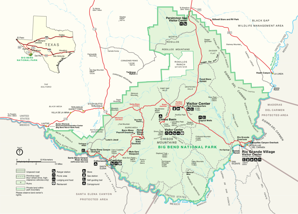
Big Bend National Park covers more than 800,000 acres along the border of Texas and Mexico. The park map shows three main types of features:
- Roads and driving routes
- Hiking trails and backcountry areas
- Visitor facilities like campgrounds and ranger stations
The park is divided into several main regions, each with its own landscape and attractions. These regions include desert areas, mountain zones, and river sections along the Rio Grande.
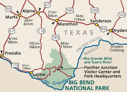
Because distances are long and services are limited, the map helps you plan fuel stops, water access, and travel time.
Main Areas on the Map
1. Chisos Basin Area
The Chisos Basin is the heart of the park and one of the most popular areas. It is located in the Chisos Mountains.
This area is clearly marked on the map and is known for:
- Cooler temperatures compared to the desert
- Popular hiking trails
- Lodging and campground facilities
Important spots on the map here include:
- Chisos Basin Campground
- Chisos Mountains Lodge
- Trailheads like Lost Mine Trail and Window Trail
If you are visiting for the first time, this is the best place to start.
2. Santa Elena Canyon Area
The Santa Elena Canyon area is located on the western side of the park. It is one of the most iconic sights in Big Bend.
The map highlights:
- Santa Elena Canyon
- Access via Ross Maxwell Scenic Drive
- Short hiking trails along the river
This area is perfect for:
- Scenic photography
- Easy hikes
- River views along the Rio Grande
3. Ross Maxwell Scenic Drive
The Ross Maxwell Scenic Drive is one of the main highlights on the park map.
This road connects the central park to Santa Elena Canyon and includes several viewpoints:
- Mule Ears Viewpoint
- Tuff Canyon
- Sotol Vista
The map shows pullouts and stops along the route, making it easy to plan your drive.
4. Rio Grande Village Area
Located on the eastern side of the park, the Rio Grande Village area is another key section on the map.
Main features include:
- Campgrounds and RV sites
- Access to river areas
- Trails like Boquillas Canyon Trail
This area is warmer and more desert-like, so always check the map for water stations and shaded spots.
5. Panther Junction (Park Headquarters)
At the center of the park map, you will find Panther Junction.
This is the main hub for visitors and includes:
- Visitor center
- Information desk
- Fuel station (important for long drives)
Most park roads connect through Panther Junction, making it a key navigation point.
Big Bend Park Roads
The park map clearly shows two types of roads:
Paved Roads
- Easy to drive with any vehicle
- Connect major attractions
- Include routes like Ross Maxwell Drive and Chisos Basin Road
Unpaved Roads
- Require high-clearance or 4WD vehicles
- Include Old Ore Road and River Road
- Marked clearly on the map
Always check road conditions before traveling, especially after rain.
Hiking Trails on the Map
Big Bend offers some of the best hiking trails in Texas, and the map helps you choose the right one.
Popular trails include:
- Lost Mine Trail (moderate, great views)
- Window Trail (family-friendly)
- South Rim Trail (long but very scenic)
Each trail is marked with:
- Distance
- Elevation
- Trailhead location
Always carry enough water, as distances can be longer than expected.
Campgrounds and Facilities
The park map also highlights important facilities such as:
Campgrounds
- Chisos Basin Campground
- Rio Grande Village Campground
- Cottonwood Campground
Services
- Visitor centers
- Restrooms
- Fuel stations
Because services are limited, use the map to plan your stops carefully.
How to Use the Map Effectively
To get the most out of your visit, follow these simple tips:
1. Plan Your Route in Advance
Distances in Big Bend are large. What looks close on the map can take hours to reach.
2. Mark Key Stops
Highlight:
- Fuel stations
- Campgrounds
- Trailheads
3. Download Offline Maps
Cell service is very limited inside the park. Always keep a downloaded or printed map.
4. Check Elevation Changes
Mountain areas like Chisos Basin are cooler, while desert areas are very hot.
Best Map Options for Visitors
There are several types of maps you can use:
1. Official Park Map
Available at visitor centers and on the National Park Service website. This is the most reliable option.
2. GPS and Mobile Maps
Apps can help, but do not depend fully on them due to poor signal.
3. Printed Maps
Always carry a paper map as backup.
Sample 2-Day Map Itinerary
Here is a simple itinerary based on the park map:
Day 1
- Enter through Panther Junction
- Explore Chisos Basin
- Hike Lost Mine Trail
- Stay at Chisos Basin Campground
Day 2
- Drive Ross Maxwell Scenic Drive
- Visit Santa Elena Canyon
- Stop at viewpoints along the way
This route covers major highlights without rushing.
Safety Tips When Using the Map
Big Bend is remote, so safety is important:
- Always carry extra water
- Keep track of fuel levels
- Avoid driving at night
- Stay on marked roads and trails
The map is your best tool to avoid getting lost.
Read Also: Joshua Tree National Park Map Guide 2026 Routes
Frequently Asked Questions
Is Big Bend National Park easy to navigate?
Yes, if you use the map properly. Main roads are well marked, but distances are long.
Can I rely on Google Maps inside the park?
Not fully. Cell service is limited, so always carry a physical map.
How long does it take to drive across the park?
It can take 2–4 hours depending on your route and stops.
Where should first-time visitors focus?
Start with Chisos Basin and Ross Maxwell Scenic Drive for the best experience.
Final Thoughts
The Big Bend National Park map is more than just a guide—it is an essential part of your trip. With vast landscapes, remote roads, and limited services, proper navigation can make your visit smooth and enjoyable.
By understanding the main regions, planning your routes, and using the map wisely, you can explore everything from mountain trails to desert canyons with confidence.
Take your time, prepare well, and enjoy one of the most unique national parks in the United States.

Rubie Rose is a travel writer with a focused specialty in USA national parks, hiking trails, and practical outdoor trip planning. She is the founder and lead writer of Park Trails Guide — an independent resource built to help everyday visitors explore America’s parks with real confidence, not just enthusiasm.