Where Is Zion National Park? Location, Map & How to Get There
If you’re wondering where Zion National Park is located, Zion is in southwestern Utah, United States, near the small town of Springdale. The park is known for its towering red and cream-colored sandstone cliffs, deep canyons, scenic drives, and popular hikes such as Angels Landing and The Narrows.
The main visitor area, Zion Canyon, is immediately next to Springdale. This is the part of the park most first-time visitors explore. Zion also includes other areas, including Kolob Canyons in the northwest section of the park.
Whether you’re driving from Las Vegas, Salt Lake City, St. George, Bryce Canyon, or the Grand Canyon, knowing Zion’s location and which entrance to use can make your trip much easier.
Where Is Zion National Park Located?
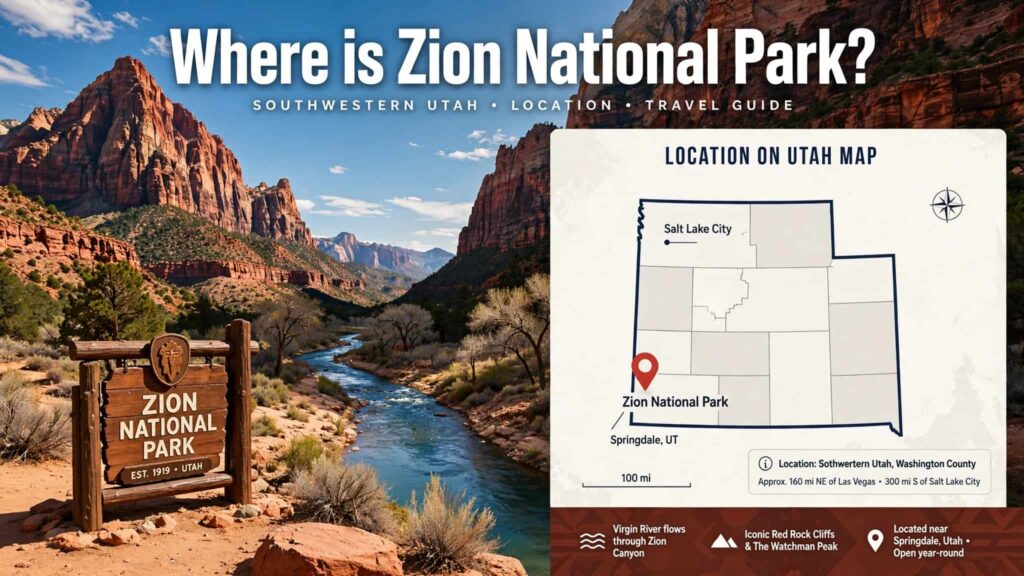
Zion National Park is located in southwestern Utah, near Springdale, Utah.
The park extends across portions of Washington, Kane, and Iron counties. The primary visitor area, Zion Canyon, is located near Springdale, while Kolob Canyons is in the northwestern part of the park near Cedar City.
Zion National Park Location at a Glance
| Information | Details |
|---|---|
| State | Utah |
| Region | Southwestern Utah |
| Main gateway town | Springdale |
| Main visitor area | Zion Canyon |
| Nearest major city | St. George |
| Nearest major airport options | Las Vegas, Salt Lake City, St. George |
| Park address | 1 Zion Park Blvd., Springdale, UT 84767 |
| Main park entrance | South Entrance near Springdale |
| Other major entrance | East Entrance |
| Kolob Canyons | Northwest section of the park |
The National Park Service lists the park’s address as 1 Zion Park Blvd., Springdale, Utah 84767.
Zion National Park on a Map

Zion is situated in the southwestern corner of Utah, relatively close to the borders of Arizona and Nevada.
On a regional map, Zion sits:
- Northeast of Las Vegas, Nevada
- Northeast of St. George, Utah
- Southwest of Cedar City, Utah
- West of Bryce Canyon National Park
- North of the Arizona border
The National Park Service’s official map shows Zion in relation to nearby destinations including St. George, Cedar City, Bryce Canyon, Kanab, Las Vegas, and the Grand Canyon.
For an interactive map and official park maps, see the National Park Service Zion maps page.
What Town Is Zion National Park Near?
The main town associated with Zion National Park is Springdale, Utah.
Springdale sits directly outside Zion’s South Entrance and is one of the most convenient places to stay if you’re visiting Zion Canyon.
The Zion Canyon Visitor Center is just inside the South Entrance, and the National Park Service lists its coordinates as approximately 37.200190, -112.987139.

Staying in Springdale can also be convenient because the town is connected with Zion Canyon by shuttle service during the shuttle season.
Which Entrance Should You Use for Zion National Park?
Zion has several areas and access points, so your best entrance depends on where you’re coming from.
1. South Entrance — Best for Zion Canyon
If you’re visiting Zion for the first time and want to see Zion Canyon, Angels Landing, The Narrows, Emerald Pools, or the main visitor center, the South Entrance near Springdale is generally the relevant entrance.
From the south, the National Park Service directs visitors toward Springdale. The South Entrance and pedestrian entrance are located at the north end of town.
This is the entrance most visitors associate with the classic Zion experience.
2. East Entrance — From Mount Carmel Junction
If you’re approaching Zion from Bryce Canyon, Highway 89, or eastern Utah, you may enter through the East Entrance.
From Mount Carmel Junction, follow Utah State Route 9 west toward Zion. The East Entrance is approximately 13 miles west of Mount Carmel Junction.
The drive through this section includes the scenic Zion-Mount Carmel Highway, which takes you through dramatic sandstone landscapes.
3. Kolob Canyons Entrance
Kolob Canyons is in the northwestern part of Zion National Park, south of Cedar City.
It is separate from the main Zion Canyon area, so don’t confuse the Kolob Canyons Visitor Center with the Zion Canyon Visitor Center near Springdale.
How Far Is Zion National Park From St. George?
St. George is one of the closest larger cities to Zion National Park.
The National Park Service describes Zion as approximately 45 miles by road northeast of St. George.
For travelers flying into the region, St. George can therefore be a useful starting point for a Zion trip.
The exact driving time can vary depending on traffic, road conditions, and your destination inside the park.
How Far Is Zion National Park From Las Vegas?
Zion is approximately 158 miles northeast of Las Vegas, Nevada, according to the National Park Service.
This makes Zion a popular destination for travelers combining southern Nevada and southern Utah into one road trip.
A typical route from Las Vegas heads northeast toward Mesquite, then continues into Utah toward the St. George area before approaching Zion.
If you’re planning a Las Vegas-to-Zion road trip, check current road conditions and navigation directions before leaving because travel times can change.
How Far Is Zion National Park From Salt Lake City?
Zion is approximately 325 miles south of Salt Lake City by road.
Because Salt Lake City is much farther away than St. George or Las Vegas, travelers coming from northern Utah should allow considerably more driving time.
A Salt Lake City trip can also be combined with other southern Utah destinations if you’re planning a longer Utah national parks road trip.
How to Get to Zion National Park by Car
Driving is one of the easiest ways to reach Zion because the park is connected to several major highways.

From Las Vegas
A common route is:
Las Vegas → I-15 North → St. George → Hurricane/La Verkin → Springdale → Zion South Entrance
This route takes you toward the main Zion Canyon area.
From St. George
A common approach is:
St. George → I-15 → UT-9 → Hurricane/La Verkin → Virgin → Springdale → Zion
From Bryce Canyon
Travelers coming from Bryce Canyon generally approach Zion from the east through the Mount Carmel Junction and East Entrance area.
The National Park Service recommends checking vehicle restrictions before using the Zion-Mount Carmel Highway because certain large vehicles cannot travel between Canyon Junction and the East Entrance.
From Salt Lake City
Travelers from Salt Lake City generally head south through Utah toward the I-15 corridor and then continue toward southwestern Utah.
Because this is a long drive, many visitors divide the trip between multiple southern Utah destinations.
Can You Drive Inside Zion National Park?
Yes, but access to Zion Canyon’s scenic road is restricted during the shuttle season.
The National Park Service states that during shuttle season, visitors can use the free shuttle to travel through Zion Canyon and Springdale. Outside shuttle season, visitors can use personal vehicles to travel through the canyon, subject to current rules and conditions.

The shuttle is particularly important if you plan to visit popular Zion Canyon trailheads.
The National Park Service currently states that you do not need a reservation or permit to ride the park shuttle.
However, some individual activities, such as Angels Landing, have separate permit requirements.
Where Is the Zion Canyon Visitor Center?
The Zion Canyon Visitor Center is located near the South Entrance, just north of Springdale.
It is an important starting point for many visitors because it provides access to the Zion Canyon shuttle system and information about the park.
The National Park Service says the visitor center parking lot has more than 350 parking spaces, although parking can fill quickly.
If you’re arriving during a busy period, arriving early can help because the NPS warns that parking spaces can fill quickly.
Is Zion National Park Close to Bryce Canyon?
Yes. Zion and Bryce Canyon are two of the most commonly combined destinations on a southern Utah road trip.
However, they are different national parks and have very different landscapes.
Zion National Park is famous for:
- Deep canyon walls
- Massive sandstone cliffs
- The Virgin River
- Angels Landing
- The Narrows
- Zion Canyon Scenic Drive
Bryce Canyon National Park is famous for:
- Hoodoos
- Amphitheater views
- High-elevation scenery
- Bryce Canyon’s distinctive rock formations
If you’re visiting both, Zion’s East Entrance and the Mount Carmel area can be relevant when planning the route.
Zion National Park Location Compared With Nearby Places
| Starting Point | Approximate relationship to Zion |
|---|---|
| Springdale, Utah | Immediately outside the South Entrance |
| St. George, Utah | About 45 miles southwest |
| Las Vegas, Nevada | About 158 miles southwest |
| Salt Lake City, Utah | About 325 miles north |
| Cedar City, Utah | Near the park’s Kolob Canyons area |
| Bryce Canyon | Northeast/east of Zion |
| Grand Canyon North Rim | Southeast of Zion |
Distances are approximate and can vary depending on the exact entrance, route, and destination. The National Park Service’s official directions and area map should be checked when planning your actual drive.
What Is the Best Way to Navigate to Zion National Park?
For the main Zion Canyon area, enter “Zion National Park Visitor Center” or “Zion Canyon Visitor Center” into your navigation app rather than simply searching for “Zion National Park.”
This can be especially useful because Zion is a large park with multiple access areas.
If your destination is:
- Angels Landing → navigate toward Zion Canyon Visitor Center, then use the appropriate shuttle/trail access.
- The Narrows → head toward Zion Canyon and the Temple of Sinawava shuttle stop.
- Zion Canyon Scenic Drive → access is through the Zion Canyon shuttle system during applicable shuttle periods.
- Kolob Canyons → use the separate Kolob Canyons entrance near I-15.
- East Entrance → approach through Mount Carmel Junction and UT-9.
Zion National Park Coordinates
For travelers using GPS coordinates, the National Park Service provides these coordinates for the Zion Canyon Visitor Center:
37.200190, -112.987139
For the Kolob Canyons Visitor Center, the coordinates are:
37.453462, -113.225640.
These coordinates are useful if you’re planning a road trip and want to distinguish between the main Zion Canyon area and Kolob Canyons.
Frequently Asked Questions About Where Zion National Park Is
Is Zion National Park in Utah?
Yes. Zion National Park is in southwestern Utah, in the southwestern United States.
What city is closest to Zion National Park?
Springdale, Utah is the primary gateway town for Zion Canyon. The town is immediately outside the park’s South Entrance.
Is Zion National Park near Las Vegas?
Yes. Zion is approximately 158 miles northeast of Las Vegas by road.
How far is Zion from St. George?
Zion is approximately 45 miles northeast of St. George by road.
Which Zion entrance is closest to Springdale?
The South Entrance is at the north end of Springdale and provides access to the main Zion Canyon area.
Can you enter Zion National Park from the east?
Yes. Zion has an East Entrance accessed via Utah State Route 9 from the Mount Carmel Junction area.
Is there more than one part of Zion National Park?
Yes. The park includes the popular Zion Canyon area as well as Kolob Canyons in the northwest. Kolob Canyons has a separate visitor center and access area.
Final Thoughts: Where Is Zion National Park?
Zion National Park is located in southwestern Utah near Springdale, with the main Zion Canyon area immediately adjacent to the town.
For most first-time visitors, the South Entrance near Springdale is the key location to remember. Travelers approaching from Bryce Canyon and eastern Utah may instead use the East Entrance, while visitors interested in the park’s Kolob Canyons section should use its separate entrance.
The park’s location also makes it convenient to combine Zion with other destinations in southern Utah and nearby Nevada and Arizona.
Before your trip, check the official NPS Zion directions and transportation information and official Zion maps for current road, shuttle, parking, and entrance information.
Quick Answer
Where is Zion National Park?
➡️ Southwestern Utah, USA
Nearest gateway town:
➡️ Springdale, Utah
Main entrance for Zion Canyon:
➡️ South Entrance
From St. George:
➡️ About 45 miles
From Las Vegas:
➡️ About 158 miles
Main GPS area:
➡️ Zion Canyon Visitor Center — 37.200190, -112.987139
Read Also: Zion National Park 1 Day Itinerary (2026): Best Stops, Shuttle & Hiking Plan
Pingback: Zion National Park Camping: Campgrounds, Reservations & Fees (2026) - Park Trails Guide