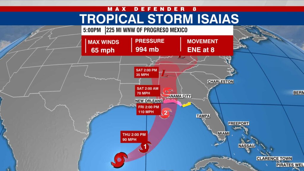
Tropical Storm Hurricane Isaias: Latest Track, Strength, Landfall Forecast and U.S. Impacts
Updated October 8, 2026: Tropical Storm Isaias has strengthened into Hurricane Isaias, becoming the first hurricane of the 2026 Atlantic hurricane season. The storm is moving toward the northern Gulf Coast and is expected to bring dangerous coastal conditions, heavy rainfall, strong winds and a significant storm-surge threat later this week.
According to the latest information from the National Hurricane Center (NHC), Isaias had maximum sustained winds of 75 mph early Thursday, October 8. The hurricane was located about 445 miles south-southwest of the mouth of the Mississippi River and was moving east-northeast at approximately 9 mph.
Hurricane Isaias Latest Update
As of the latest NHC advisory available Thursday morning, Hurricane Isaias had:
- Maximum sustained winds: 75 mph
- Minimum central pressure: 981 mb
- Movement: East-northeast at 9 mph
- Location: Approximately 23.1°N, 91.7°W
- Position: About 445 miles south-southwest of the mouth of the Mississippi River
- Status: Category 1 hurricane
Hurricane Hunter aircraft are investigating the storm, and the National Hurricane Center says additional strengthening is expected through early Friday. NHC forecasts Isaias to remain a strong hurricane as it approaches the northern Gulf Coast Friday night.

Where Is Hurricane Isaias Heading?
Hurricane Isaias is currently over the Gulf of America and is moving generally east-northeastward. Forecasters expect the storm to turn toward the northeast and north later Thursday and Friday.
The current forecast track takes Isaias toward the northern Gulf Coast, with landfall expected within the warning area late Friday or early Saturday. Because tropical cyclone forecasts can change as new observations become available, residents should follow the latest local National Weather Service and NHC advisories rather than relying on an older forecast map.
Areas along the northern Gulf Coast are watching the storm particularly closely, including parts of Louisiana, Mississippi, Alabama and Florida.
Hurricane Isaias Landfall Forecast
The exact landfall location and intensity can still change.
The latest NHC forecast calls for Isaias to approach the northern Gulf Coast on Friday night, with hurricane conditions possible in the warning area. Tropical-storm conditions are expected to begin earlier on Friday.
Earlier forecasts placed the potential landfall zone broadly between the eastern Louisiana coast and the Florida Panhandle. Current warnings and local forecasts should be checked before making travel or evacuation decisions.
Storm Surge Threat
Storm surge is one of the most serious hazards associated with Hurricane Isaias.
The latest NHC advisory indicates that 5 to 7 feet of storm surge could occur somewhere between Ocean Springs, Mississippi, and Indian Pass, Florida, if peak surge coincides with high tide.
Storm surge can push seawater inland very quickly, especially in low-lying coastal communities. Even locations outside the exact center of the hurricane can experience dangerous coastal flooding.
Residents in coastal areas should pay attention to official evacuation orders and local emergency-management instructions.
Heavy Rain and Flooding Risk
Isaias is also expected to produce substantial rainfall across the Gulf Coast and parts of the Southeast.
The NHC forecasts approximately 3 to 7 inches of rain, with isolated totals reaching 10 inches, across parts of the central U.S. Gulf Coast from southeastern Louisiana to the Florida Panhandle from Friday through the weekend.
Additional rainfall of around 1 to 3 inches, with locally higher amounts, could extend farther inland toward areas including the Tennessee Valley and Carolinas.
Heavy rainfall may cause:
- Flash flooding
- Urban flooding
- River flooding
- Dangerous road conditions
- Rapid rises in smaller waterways
Flooding can become a major threat even in locations that do not experience hurricane-force winds.
Tornado Threat From Hurricane Isaias
Another concern is the possibility of tornadoes.
The National Hurricane Center says isolated tornadoes could occur Friday night in coastal parts of Alabama and the Florida Panhandle. The threat could continue into Saturday across eastern Alabama, western Georgia and the Florida Panhandle.
Tornadoes associated with tropical systems can develop quickly, meaning residents should not rely solely on the hurricane’s center track when assessing their local risk.
Why Isaias Is Getting So Much Attention
Hurricane Isaias is notable because it is the first Atlantic hurricane of the 2026 season, arriving unusually late in the year.
The 2026 Atlantic season had been unusually quiet compared with many recent hurricane seasons. AP reported that Isaias formed amid a powerful El Niño pattern that had generally suppressed Atlantic hurricane development, while conditions in the Gulf became more favorable for strengthening.
The storm’s development has therefore attracted significant attention from meteorologists, emergency officials and residents along the Gulf Coast.
Gulf Coast Energy Operations Affected
The storm is also affecting the U.S. energy sector.
Reuters reported that major oil companies including Shell and Chevron have reduced offshore operations in the Gulf of Mexico as Isaias approaches. Shell evacuated personnel from several offshore facilities and shut production at multiple assets, while Chevron also began shutting in some production and moving personnel ashore.
Reuters separately reported that a portion of Gulf oil and natural-gas production had already been shut in as companies prepared for the storm.
These disruptions could have implications for regional fuel and energy markets if the storm causes prolonged operational problems.
What Residents in the Gulf Coast Should Do
People living in areas under hurricane, storm-surge or tropical-storm warnings should follow instructions from local officials.
Before conditions deteriorate, residents should consider:
- Checking their local evacuation zone.
- Following evacuation orders immediately if issued.
- Securing outdoor furniture and loose objects.
- Charging phones and essential electronic devices.
- Keeping several days of drinking water and food available.
- Having necessary medicines and important documents ready.
- Avoiding flooded roads and standing water.
- Monitoring official weather alerts throughout the storm.
Do not attempt to drive through floodwater. Water depth can be difficult to judge, and even relatively shallow moving water can sweep vehicles off roads.
Is Hurricane Isaias the Same Storm as the 2020 Hurricane?
No. Hurricane Isaias in 2026 is a new storm, although it has the same name used by a previous Atlantic tropical cyclone.
The name Isaias was previously used in 2020, when Hurricane Isaias affected parts of the Caribbean and the eastern United States. Atlantic hurricane names are reused on a six-year cycle unless a name is retired because of the storm’s historical impact.
That is why the name has appeared again during the 2026 Atlantic hurricane season.
Hurricane Isaias vs. Tropical Storm Isaias
Many people searching for “Tropical Storm Hurricane Isaias” may see both terms because the storm recently transitioned from a tropical storm into a hurricane.
A tropical cyclone becomes a hurricane when its maximum sustained winds reach at least 74 mph.
Isaias crossed that threshold Wednesday night. NHC aircraft observations confirmed maximum sustained winds of 75 mph, officially making it a hurricane.
What Happens Next?
The next major developments to watch are:
- Whether Isaias strengthens further before reaching the Gulf Coast.
- The exact landfall location.
- Changes to storm-surge warnings.
- Rainfall and flooding forecasts.
- The potential for tornadoes across parts of the Southeast.
- Local evacuation and emergency declarations.
Because the storm is still strengthening, residents should use the latest NHC advisory and local National Weather Service forecasts rather than older social-media posts or outdated forecast graphics.
Bottom Line
Hurricane Isaias is now the first hurricane of the 2026 Atlantic season and is approaching the northern Gulf Coast. As of the latest NHC update available Thursday, the storm had 75 mph sustained winds and was expected to strengthen further before approaching the coast Friday night.
The biggest concerns are storm surge, hurricane-force winds, heavy rainfall, flooding and isolated tornadoes. Communities along the Gulf Coast should continue monitoring official warnings as the forecast evolves.
For the most current storm information, residents should rely on the National Hurricane Center, National Weather Service and their local emergency-management authorities.